source
By KATHY SHIRLEY
EXPLORER Correspondent
Tax Break Rekindled Interest
Shale Gas Exciting Again
An Atrium Shale outcrop at the Paxton Quarry in northern Michigan.
Photo courtesy of Gas Research Institute
See related story: Lewis Not Overlooked Anymore
Shale gas production is certainly nothing new in the United States. In fact, the first commercial gas shale well was drilled in New York in the late 1820s – nearly 40 years before Colonel Drake drilled his famous oil well in Pennsylvania.
Still, there’s a new - some might say urgent - sense of excitement when it comes to the role of shale gas production in today’s energy mix, as well as its potential for the coming years.
“Over the next decade we expect the gas industry will continue to expand the shale gas play frontiers as new areas are evaluated and we learn more about the geology of shale gas resources,” said David G. Hill, manager, emerging resources, with the Gas Technology Institute.
Gas shales, he said, are classified as continuous type natural gas plays - accumulations that are pervasive throughout large geographic areas and offer long-lived reservoirs with attractive finding costs.
“The major exploration risk in most shale gas plays is generally not the drilling of a truly dry hole, but rather in not obtaining economically viable gas production rates,” Hill said. “Most shales have very low matrix permeabilities and require the presence of extensive natural fracture systems to sustain commercial gas production rates.”
In shale reservoirs, natural gas is stored three ways:
As free gas within the rock pores.
As adsorbed gas on organic material.
As free gas within the system of natural fractures.
These different storage mechanisms, Hill said, affect the speed and efficiency of gas production.
Modern gas shale production was initially spurred by the Section 29 non-conventional fuels production tax credit, but that tax credit expired in 1992, and operators have continued to expand gas shale programs. Today over 28,000 gas shale wells produce nearly 380 billion cubic feet of gas yearly from five U.S. basins:
Appalachian.
Michigan.
Illinois.
Fort Worth.
San Juan.
In 1998 fractured shale gas reservoirs supplied 1.6 percent, or .3 trillion cubic feet of total U.S. dry natural gas production and contained 2.3 percent or 3.9 trillion cubic feet of total U.S. proved natural gas reserves. Over the past decade shale gas production has increased by a factor of 2.5, growing from 148.6 billion cubic feet of gas in 1989 to 380 billion cubic feet in 1999.
The shale gas resource base in the lower 48 states is significant. According to GTI, gas-in-place resource estimates for the five main gas shale plays total 581 trillion cubic feet of gas, and recoverable resource estimates range from 31 to 76 trillion cubic feet.
These figures are considered conservative since estimates for the Barnett Shale in the Fort Worth Basin and the Lewis Shale (see related story, page 26) are not available.
Hill commented that “each new shale gas play has presented technical challenges that operators have to overcome by identifying and solving shale-specific problems.
“But,” he added, “success in these relatively low-cost plays has sparked a resurgence of industry interest in evaluating the production potential of the shale gas resources present in basins throughout the United States.”
A Stimulating Story
The first shale gas production in the United States came from the Appalachian Basin, where by 1926 the Devonian shale gas fields were the world’s largest known occurrence of natural gas. At year-end 1999 the basin contained over 21,000 gas shale wells, producing approximately 120 billion cubic feet of gas a year.
Technically recoverable resource estimates for the Appalachian Basin range from 14.5 to 27.5 trillion cubic feet of gas.
The basin’s Devonian-age shales extend from southwestern New York to eastern Kentucky and central Tennessee. The majority of its shale gas production has been from the Big Sandy and associated fields in Kentucky and southwestern West Virginia, where the primary target is the Huron member of the Upper Devonian Ohio Shale.
Well recoveries vary considerably, ranging from less than 100 million cubic feet of gas to more than one billion cubic feet. The average well produces 250 to 350 million cubic feet over a productive life of 30 years.
“One of the biggest technical challenges in the Ohio Shale has been in the area of stimulation,” Hill said. “While some wells flow gas naturally, over 90 percent require some form of stimulation to achieve commercial production rates.”
Over the years the Appalachian Devonian shales have been a test bed for a variety of stimulation technologies that include:
“Shooting” a well with gelatinated nitroglycerine.
High energy gas fracturing.
Nitrogen- and carbon dioxide-based foam fracturing.
Straight gas fracturing without proppant.
High angle and horizontal completions.
A number of variations on basic fracturing fluids and chemicals.
Two more recent innovations are the use of liquid carbon dioxide and sand, and cryogenic nitrogen.
As with most stimulation applications, Hill said, no single technique or fluid system has worked universally.
“The proximity to large East Coast markets, low transportation costs, long lived reserves and high success rates will continue to make the Ohio Shale an attractive target in the Appalachian Basin,” he said.
“However, considering the maturity of the play, the greatest challenge to continued success will be expanding the productive limits of historic play areas with new stimulation technologies.”
A Tale of Two Basins
The Antrim Shale in the Michigan Basin spurred the current gas shale interest in the United States.
Initially the Section 29 tax credit spurred activity in the Antrim Shale, but new technology, an understanding of the mechanisms controlling production and operational efficiency gains by operators have sustained activity in the play.
The Devonian-age Antrim Shale reaches a depth of about 3,000 feet in the center of the basin. Operators, however, are developing the shale along the shallow northern and western rim of the basin, where well depths range from 400 to 2,500 feet and wells cost about $240,000 to $280,000 to drill and complete.
The primary targets are the Lachine and Paxton members of the Lower Antrim.
Resources estimates range from 35 trillion to 76 trillion cubic feet of gas, with technically recoverable gas reserves estimated at 11 to 18.9 trillion cubic feet. The average well in the Antrim Shale produces around 116 thousand cubic feet of gas a day, and production has grown from 12 billion cubic feet from 154 wells in 1988 to over 190 billion cubic feet of gas from 6,500 wells in 1999.
In fact, the 221 Antrim Shale wells drilled in 1999 accounted for three-quarters of the drilling activity in the Michigan Basin.
“The Antrim play will continue to develop,” Hill said, “as operators evaluate new completion technologies, recomplete wells in the upper Antrim Shale, conduct restimulation programs and test new areas for production potential.”
The New Albany Shale in the Illinois Basin has a long producing history, too, but activity in this region has not progressed at the same rate as the Ohio Shale or the Antrim Shale.
In the 1990s activity in this play was driven by success in the Antrim. Many of the players in Michigan considered the New Albany a viable target and approached it using the Antrim model for development.
Activity in the New Albany Shale peaked in 1996 with 90 wells, but has since declined to just 16 wells in 1999.
Operators are currently experimenting with various drilling and completion techniques in an attempt to improve well performance and reduce costs. Well costs have ranged from $100,000 to $150,000, depending on water lifting requirements and the type, number and size of stimulation treatments needed.
Efforts also are under way to better identify the mechanisms controlling gas occurrence and productivity.
Gas resource estimates for the New Albany Shale range from 86 to 160 trillion cubic feet of gas with estimates of technically recoverable reserves ranging from 1.9 to 19.2 trillion cubic feet.
The Barnett - and Beyond
Mitchell Energy & Development Co. has been developing the Barnett Shale in the Fort Worth Basin in the northeast sector of central Texas since 1981.
The Mississippian-age Barnett Shale is one of the most uniform statigraphic units in the basin, outcropping along the flanks of the Llano uplift in central Texas, where it is about 30 to 50 feet thick.
The shale dips gently and thickens to the north, reaching a maximum depth of around 8,500 feet and a maximum thickness of almost 1,000 feet near the Texas-Oklahoma border.
Barnett Shale production was first established in the Newark East Field in Wise and Denton counties, where it grew from less than one billion cubic feet of gas from 25 wells in 1985 to 19.2 billion cubic feet from 306 wells in 1995. During the past five years, production has more than doubled to 40.6 billion cubic feet from over 500 wells.
The Barnett is found at 6,500 to 8,000 feet in the Wise and Denton counties area and is about 500 feet thick. It is divided into lower and upper intervals by the Forestburg Limestone.
AFE Oil and Gas Consultants expanded the Barnett Shale play area in 1997 with a discovery in Dallas County, approximately 12 miles southeast of the Newark East Field. The firm continued to expand its play area with three wells in northeastern Tarrent County.
“Initially, Mitchell Energy completed only the lower Barnett interval, using massive hydraulic fracturing treatments,” Hill said. “Well costs typically ranged from $600,000 to $800,000, including $200,000 to $300,000 in stimulation costs.”
In 1998 the firm experimented with a new stimulation technique that employed water as the fracturing fluid, required significantly less proppant and was about 60 percent less expensive than the conventional stimulation treatments.
“The technique proved successful,” Hill said, “and has since been implemented field wide.”
Last September Mitchell Energy demonstrated a technique for economically completing the upper Barnett Shale interval, increasing reserves in their core area by 25 percent, or 250 million cubic feet per well, and expanding the play to previously marginal areas.
This new completion technique in combination with a 50-acre spacing infill well drilling program is expected to allow Mitchell Energy to increase its Barnett Shale gas production and open up new areas for exploitation.
Hill said while the bulk of gas shale production has come from these reservoirs in the San Juan, Appalachian, Michigan, Illinois and Fort Worth basins, there are a multitude of opportunities to expand shale gas activity in other regions of the country.
“Three key advantages of shale gas plays are moderate exploration costs, high success rates and slow production decline rates,” he said. “The rapid growth in the late 1980s and early 1990s in the Antrim Shale, which is being repeated today in the Fort Worth and San Juan basins, is driven by the powerful economic incentives of low risks and low reserve finding costs.
“Each of these plays has presented new technical challenges for operators to overcome,” he added, but “their success has sparked a resurgence of industry interest in evaluating the production potential of shale gas resources in basins throughout the United States.”
Wednesday, August 13, 2008


The Father Of The Barnett Shale Gas Play
source
The Father of the Barnett
A unique set of factors converged to kick off the Barnett boom. New technologies such as artificial fracturing and horizontal drilling made it possible to extract large amounts of gas from shales. The relatively high price of gas in recent years made it economically viable.
Yet according to Eric Potter, neither of these would have mattered without one critical element:
“It wasn’t high tech. It was persistence and experimentation on the part of one company that got this boom going.”
Mitchell Energy had produced gas from a shallower formation, the same formation that John Jackson had discovered in the 1950s. That production was waning.
“They began looking around for what could be done in the same area,” says Potter. “They had always noticed that when you drilled through the Barnett, you would get a gas show. But everyone thought you wouldn’t get much gas.”
Even though shale may have a lot of pores with the ability to store gas, it is not very permeable. In other words, it does not have many connections between the pores and so trapped oil and gas can not flow easily.
“Mitchell Energy sunk a lot of money over a long period into learning how to stimulate the rock so it would flow,” says Potter. Their first attempts were expensive “massive hydraulic frac jobs.” They would pump a very large volume of fluid and sand down a well bore to crack the rock and give it more permeability. At first, they got the gas flowing, but the methods and materials were expensive. So they wondered if they could pump less fluid and get the same effect.
“They arrived at something called a light sand frac,” says Potter. “Suddenly it was economical and at the same time—in the mid-1990s—the price of gas was rising. By the late 1990s, they had perfected the technique in vertical wells and started applying it to several hundred wells. That’s when it came to the attention of industry.”
Potter first heard about these early successes from a Mitchell employee in 1996.
“I didn’t think it would have the kind of impact it did,” he says. “I wasn’t the only one. Most people in industry were surprised and had difficulty adjusting to the notion that shale could produce in commercial amounts over such a wide area. There were only a few companies that appreciated the value of hydraulic fracture technology applied on such a large scale.”
When thermally-mature organic-rich mudstone is drilled into, the pressure drops and gas is released by a process called desorption. Early estimates of how much gas would be given up by the Barnett Shale turned out to be far too low. The experiments were run again and it was realized that this shale would give up much more gas than was previously thought.
“Then it was realized, oh, if you scale that up to the whole area and then to the whole county and up to the whole Basin, the amounts of gas are really quite prodigious,” says Potter. “People became aware of that in 2002 and 2003 and that really got the ball rolling.”
Mitchell Energy already had critical infrastructure in place to process and transport gas. So they could quickly and economically take advantage of the discovery.
“It took George Mitchell 18 years to make it work,” notes Larry Brogdon, partner and chief geologist for Four Sevens Oil Company. “He is the father of the Barnett Shale. He was tenacious. He started in 1981 and it really didn’t take off until 1999. And even then, it took a long time to develop it.”
by Marc Airhart
The Father of the Barnett
A unique set of factors converged to kick off the Barnett boom. New technologies such as artificial fracturing and horizontal drilling made it possible to extract large amounts of gas from shales. The relatively high price of gas in recent years made it economically viable.
Yet according to Eric Potter, neither of these would have mattered without one critical element:
“It wasn’t high tech. It was persistence and experimentation on the part of one company that got this boom going.”
Mitchell Energy had produced gas from a shallower formation, the same formation that John Jackson had discovered in the 1950s. That production was waning.
“They began looking around for what could be done in the same area,” says Potter. “They had always noticed that when you drilled through the Barnett, you would get a gas show. But everyone thought you wouldn’t get much gas.”
Even though shale may have a lot of pores with the ability to store gas, it is not very permeable. In other words, it does not have many connections between the pores and so trapped oil and gas can not flow easily.
“Mitchell Energy sunk a lot of money over a long period into learning how to stimulate the rock so it would flow,” says Potter. Their first attempts were expensive “massive hydraulic frac jobs.” They would pump a very large volume of fluid and sand down a well bore to crack the rock and give it more permeability. At first, they got the gas flowing, but the methods and materials were expensive. So they wondered if they could pump less fluid and get the same effect.
“They arrived at something called a light sand frac,” says Potter. “Suddenly it was economical and at the same time—in the mid-1990s—the price of gas was rising. By the late 1990s, they had perfected the technique in vertical wells and started applying it to several hundred wells. That’s when it came to the attention of industry.”
Potter first heard about these early successes from a Mitchell employee in 1996.
“I didn’t think it would have the kind of impact it did,” he says. “I wasn’t the only one. Most people in industry were surprised and had difficulty adjusting to the notion that shale could produce in commercial amounts over such a wide area. There were only a few companies that appreciated the value of hydraulic fracture technology applied on such a large scale.”
When thermally-mature organic-rich mudstone is drilled into, the pressure drops and gas is released by a process called desorption. Early estimates of how much gas would be given up by the Barnett Shale turned out to be far too low. The experiments were run again and it was realized that this shale would give up much more gas than was previously thought.
“Then it was realized, oh, if you scale that up to the whole area and then to the whole county and up to the whole Basin, the amounts of gas are really quite prodigious,” says Potter. “People became aware of that in 2002 and 2003 and that really got the ball rolling.”
Mitchell Energy already had critical infrastructure in place to process and transport gas. So they could quickly and economically take advantage of the discovery.
“It took George Mitchell 18 years to make it work,” notes Larry Brogdon, partner and chief geologist for Four Sevens Oil Company. “He is the father of the Barnett Shale. He was tenacious. He started in 1981 and it really didn’t take off until 1999. And even then, it took a long time to develop it.”
by Marc Airhart
Barnett Shale Gas
The gas being produced from the Barnett Shale represents one of the most exciting developments in the oil and gas industry in decades.
Peter
source
Barnett Boom Ignites Hunt for Unconventional Gas Resources
January 2007
The global hunt for unconventional gas reserves recently turned to an unlikely spot—a patch of north central Texas that already seemed tapped out after 50 years of intense oil and gas drilling.
Technology, economics and one man’s persistence transformed the Barnett Shale formation of the Fort Worth Basin into a booming new frontier.
As conventional petroleum reserves dwindle in the U.S., public pressure mounts to reduce the country’s dependence on foreign energy, and the price of oil and gas rises, energy companies are setting their sights on “unconventional” domestic sources. These include oil sands, coal beds and shales.
In less than a decade, the Barnett Shale play has become the largest natural gas play in the state of Texas and, as new wells sprout like bluebonnets across the Fort Worth region, it might soon become the largest in the nation.
“This play already covers parts of 15 or more counties,” says Eric Potter, associate director of the Bureau of Economic Geology at the University of Texas at Austin. “It compares favorably with the biggest of the old oil booms of the early 20th century.”
Of course this boom is different. The concrete-like shale gives up its gas grudgingly. So individual wells tend to be smaller and more expensive to operate.
Peter
source
Barnett Boom Ignites Hunt for Unconventional Gas Resources
January 2007
The global hunt for unconventional gas reserves recently turned to an unlikely spot—a patch of north central Texas that already seemed tapped out after 50 years of intense oil and gas drilling.
Technology, economics and one man’s persistence transformed the Barnett Shale formation of the Fort Worth Basin into a booming new frontier.
As conventional petroleum reserves dwindle in the U.S., public pressure mounts to reduce the country’s dependence on foreign energy, and the price of oil and gas rises, energy companies are setting their sights on “unconventional” domestic sources. These include oil sands, coal beds and shales.
In less than a decade, the Barnett Shale play has become the largest natural gas play in the state of Texas and, as new wells sprout like bluebonnets across the Fort Worth region, it might soon become the largest in the nation.
“This play already covers parts of 15 or more counties,” says Eric Potter, associate director of the Bureau of Economic Geology at the University of Texas at Austin. “It compares favorably with the biggest of the old oil booms of the early 20th century.”
Of course this boom is different. The concrete-like shale gives up its gas grudgingly. So individual wells tend to be smaller and more expensive to operate.

In less than a decade, the Barnett Shale play has become the largest natural gas play in the state of Texas and, as new wells sprout like bluebonnets across the Fort Worth region, it might soon become the largest in the nation.
“The East Texas gushers would win out hands down,” says Potter. “But there are so many [Barnett] wells that even though they are modest, the total output is going to be huge.“
This play is also different because much of the untapped gas lies under the highly populated Fort Worth metropolitan area. Oil and gas companies are finding new challenges drilling in an urban setting.
Now, some experts are wondering if the boom can go global. The search is on for similar shale formations around the world, including the Fayetteville Shale in Arkansas.
Going to the Source
The fact that there is a Barnett boom at all reflects a tectonic shift in thinking. In the past, drillers bypassed the source rock that generated the oil and gas and focused on the reservoir rock, where the resources were easier to extract. Typically, oil or gas exits from the source rock and migrates to places where it is trapped. And those traps—conventional fields—typically do not cover a large area.
“There would be a field here and then a lot of blank space and then a few miles over there would be another field,” says Potter. “But this kind of play, it just covers county after county. You’re looking at thousands and thousands of wells covering the land.”
According to Eric Potter, the 5,500 wells currently pumping gas in the Barnett Shale play will ultimately generate on the order of $35 billion for their owners and through an economic ripple effect, $100 billion for the Texas economy.
With new technologies for coaxing gas out of shales, drillers see the Barnett as both source and reservoir. One such technology is artificial fracturing—in which operators pump water and sand down a well to create fractures that liberate more gas from the rock.
Potter and his colleagues at the Bureau are analyzing the properties of shales across the state. Ultimately, they hope to apply their work to similar rock formations anywhere in the world.
“Now any kind of mudrock or shale that’s black, organic rich, reasonably thick, and reasonably deep we’re interested in,” says Potter. “The question is, all shales are not alike, so what makes a shale prospective as opposed to one that is not prospective? We don’t really know that yet.”
Wise Investment
Before he died in 2003, oilman and philanthropist John Jackson donated to The University of Texas at Austin royalty interests in roughly a thousand wells in the Fort Worth Basin, part of the bequest that led to the formation of the Jackson School of Geosciences. These wells were producing oil and gas from the younger Bend Conglomerate formation just above the Barnett.
The Bend Conglomerate was formed during the Pennsylvanian age, meaning it was laid down about 290 to 320 million years ago. The Barnett Shale, a marine basinal deposit of middle to late Mississippian age, was laid down about 320 to 360 million years ago.
Could the same wells produce significant amounts of gas from the older, deeper Barnett shale? Potter and his colleagues at the Bureau helped the University assess the long-term potential of the University’s royalty interests.

Royalty interests on about a thousand wells donated by John Jackson, mostly in Wise County, Texas help build one of the world’s premier geoscience programs at the Jackson School.
“The short answer is that we think that most of that acreage has quite good potential in the Barnett,” says Potter. “Eight of the top ten Jackson School royalty wells are producing from the Barnett Shale. We are forecasting that most of these holdings will produce from the Barnett.”
The University receives on average about two percent of the gross revenue from wells it holds royalty interests on. That money is being used to build one of the world’s premier geosciences programs at the new Jackson School. Because the money goes into general funds, it supports all of the activities of the school, including dean Eric Barron’s priorities: to create the world’s most student-centered earth science program, to attract and retain the best research talent, to increase the breadth and depth of the faculty and research community and to establish the “fabric of a great school.”
Researchers at the Bureau are providing technical analysis to help stimulate additional drilling and production in Wise County, where most of the University’s royalty interests are located. Emphasis so far has been on mapping the basic stratigraphic and structural framework, tracking successful drilling in the less developed southern part of the play, mapping similar conditions in Wise County, and remapping the thermal maturity of the formation. The maturity seems to relate directly to the gas to oil ratio, one of the key factors controlling gas flow rates.
According to Potter, the 5,500 wells currently pumping gas in the Barnett Shale play will ultimately generate on the order of $35 billion for their owners. As those companies pay taxes and wages, and as their employees and contractors in turn spend their money, there is an economic ripple effect, creating an overall value of about $100 billion to the Texas economy.
Of course, that is only counting current wells. Potter predicts that if gas prices stay relatively high, tens of thousands of new wells will be drilled in the coming decades.
“It’s a ubiquitous reservoir,” says Larry Brogdon, partner and chief geologist for Ft. Worth based Four Sevens Oil Company. “It’s everywhere. You can not drill a well without hitting the Barnett, and the gas is always there. The question is can you get it out or not.“
So far, operators have extracted 2 trillion cubic feet of gas from the Barnett Shale play. At about 1.5 billion cubic feet a day, that’s about 2 percent of the daily natural gas consumption of the U.S.
“When you can go from nothing to the second largest producing gas field in the country in a matter of just a few years, that makes a statement,” says Rich Pollastro, a geologist with the U.S. Geological Survey in Lakewood, Colorado. “That’s huge. And it could potentially become the largest producing field in the country. That was a real awakening for the country and now because of its success, industry and nations are looking at it worldwide.”
The Next Barnett?
In the summer of 2004, Southwestern Energy announced that the Fayetteville Shale formation in the Arkoma Basin had many of the same characteristics that made the Barnett Shale formation so desirable for gas production. Before the announcement, the company had quietly acquired mineral leases on nearly a half million acres of land.
The announcement set off another gas boom. Oil and gas operators familiar with the Barnett Shale rushed to Arkansas to get in on the action.
“The analog would be like a 19th century gold rush,” says Ed Ratchford, geology supervisor for the Arkansas Geological Commission in Little Rock. “Everyone stakes a claim. You don’t say this place is going to be better than this place. You don’t have time. People were leasing thousands of acres a day.”
Ratchford and his team maintain a well log library, a collection of well cuttings and cores from oil and gas wells across Arkansas. They used these to conduct geochemical tests on samples from the Fayetteville Shale and produce a regional picture of where good gas prospects were likely to be.
“We had companies all over us waiting for us to get this stuff done,” says Ratchford. “They were sitting out in the parking lot before we opened up. We were the only ones that had this information. It was critical for helping the operators know where to lease.”
In the excitement, many companies took a gamble on mineral leases.
Locations of the Barnett Formation. Source: USGS.
“We had a lot of companies that had leased before the report came out,” says Ratchford. “Then they had a big golf ball in their throats saying, ‘I wish I hadn’t leased here.’ That’s the risk you run when you lease big tracts of land in a boom without having the luxury of doing the science first.”
“Some of those companies are going to make a lot of money,” notes Ratchford, “some are going to be doing tax write offs. That’s the nature of exploration. In a situation like this, where there’s a frenzy, there are going to be winners and losers.“
It’s too early to tell how much gas will ultimately be recoverable from the Fayetteville Shale. Southwestern Energy, still the largest lease holder in the play, estimates that they will recover 17 trillion cubic feet of gas.
The future looks good for the Fayetteville play. Ratchford expects the number of wells producing in the area to rise from the current 80 to a couple hundred and that gas will be extracted for at least 15 or 20 years.
He also notes that oilfield services provider Schlumberger has recently built a 30,000 square foot facility in Conway, Arkansas and will employ approximately 100 employees at that facility. “They would not do this if they didn’t believe this would be a long term venture,” says Ratchford.
Other areas that have generated interest for possible large shale gas plays are the Caney and Woodford formations in Oklahoma, the Floyd formation in the Black Warrior Basin of northwest Alabama, and the Barnett and Woodford formations in the Permian Basin of Texas.
It remains to be seen if the rising star of the Barnett Shale play will be eclipsed by other gas plays.
“The Barnett might be as good as it gets,” says Pollastro. “No one knows for sure.”
He produced the U.S. Geological Survey’s assessment of the Fort Worth Barnett shale play in 2003. At the time, he estimated that it held a remaining volume of 26 trillion cubic feet of recoverable unconventional gas. Now he’s evaluating the Barnett and Woodford formations in the Permian Basin, where drillers have experienced mixed results.
“It’s a different animal,” he says. “The Barnett in the Delaware Basin part of the Permian Basin is deeper and is more clay rich, so at present it’s not working like everybody thought it would. It’s not as rich in organic material as the Fort Worth Basin. I think there’s good potential, but I think there will be a steep learning curve.”
by Marc Airhart
Tuesday, August 5, 2008
Doomsday Is Approaching For Climate Change Alarmists
Professor Will Alexander of The University of Pretoria, South Africa is quite outspoken and to the point in his dismissal of the myth of man-caused global warming. It looks like his article is not "peer-reviewed", which probably makes it all the more valuable. Global warming alarmists are going to be have an increasingly difficult time silencing their growing number of critics.
Peter
Fraudulent Science
Will Alexander
My advice to climate alarmists is that now is an appropriate time to start planning your exit strategy. The whole IPCC/UNFCCC edifice is about to disintegrate. I described these events in my recent memos. My position during all these years has been very simple. I could find no evidence of unnatural changes in the officially published hydrometeorological records. In the attached memo, for the first time I go on the attack. Not only is there no believable evidence in the data to support climate alarmism, but the evidence refutes the IPCC’s claims and completely undermines its position.
I have attached two files, my memo and the evaporation histograms in file Evaporation.pdf. What is the future of climate alarmism and its associated research? There is none. The globe is cooling, the glaciers are advancing and Bangladesh is not being inundated by rising sea levels. Public interest is falling and the media are becoming more critical. The possibility of nations reaching agreement on meaningful actions to control, let alone reduce, their undesirable emissions is receding by the day. The basic science underlying the IPCC’s position is being eroded away, stone by stone.
There is a growing and very perceptible groundswell of public and scientific opinion that is questioning the very basis of climate alarmism. The alarmists are no longer dealing with a gullible public and ambitious poticians. Here in South Africa, we are going through turbulent times. Honest, conscientious and knowledgeable scientists have a professional and moral duty to examine the scientific basis for the alarmist claims and report their findings. The most efficient method to publicise their results is the Internet. Others can use the information to complement their own studies. The rising tide of knowledge will become unchallengeable. This is the route that I have followed. Ever since I became involved in this climate change issue, way back in 1993, I reported that there is no evidence in the data to support the alarmist claims. The other side insisted that their computer models were infallible and that I was wrong. I did not try to prove that they were wrong. I just kept reiterating that there was no evidence in the data to support their theories.
This was also my 93-page message to the Stern Review. You will recall their basic argument. Increasing undesirable greenhouse gas emissions result in rising global temperatures. These increase evaporation from the oceans. Energy is thereby transferred to the atmosphere. This in turn amplifies the greenhouse effect. All of this results in an intensification of the hydrological cycle: more extreme floods and droughts, etc etc. All of this results in threats to our precious plant and animal species and human life on this planet. (But as the analysis shows,) there is no evidence of changes in open water surface evaporation that are synchronous with global temperature changes during the period of record. This is a body blow for the climate alarmists. There is absolutely no evidence that global warming increases evaporation from open water surfaces, including the oceans.
If the alarmists try to follow the adaptation route, they will be squashed underfoot by civil engineers and applied hydrologists. There is only one remaining option. Abandon ship. In the meantime, you may find this item on the web interesting.
See Will’s latest memo here.
Will Alexander is a Professor at the University of Pretoria, South Africa
University of Pretoria professor: MAN-MADE global warming is not real
allAfrica.com: Namibia: Climate Change a Fallacy - South African Professor (Page 1 of 1)
MAN-MADE global warming is not real, a Professor from the University of Pretoria charged in Windhoek last week.
Professor Will Alexander claimed that claims by environmentalists that climate change was real were not true and if the world was warmer now, it was simply caused by natural climatic variability....He said while environmentalists claim that rainfall will decrease because of climate change, rainfall has in fact increased during the last century.According to him, it was also not true that the frequency of tropical cyclones, droughts and floods will increase."There is no evidence on that," said Alexander.He claimed that disasters such as this year's floods in the North were caused by natural climatic variability and people were affected because they were now living in areas prone to natural disasters, whereas before they lived in higher-lying areas.But Dr Omu Kakujaha from the University of Namibia said whether climate change or climate variability was real or not, it has a negative impact on Namibia's economy.
-->
Peter
Fraudulent Science
Will Alexander
My advice to climate alarmists is that now is an appropriate time to start planning your exit strategy. The whole IPCC/UNFCCC edifice is about to disintegrate. I described these events in my recent memos. My position during all these years has been very simple. I could find no evidence of unnatural changes in the officially published hydrometeorological records. In the attached memo, for the first time I go on the attack. Not only is there no believable evidence in the data to support climate alarmism, but the evidence refutes the IPCC’s claims and completely undermines its position.
I have attached two files, my memo and the evaporation histograms in file Evaporation.pdf. What is the future of climate alarmism and its associated research? There is none. The globe is cooling, the glaciers are advancing and Bangladesh is not being inundated by rising sea levels. Public interest is falling and the media are becoming more critical. The possibility of nations reaching agreement on meaningful actions to control, let alone reduce, their undesirable emissions is receding by the day. The basic science underlying the IPCC’s position is being eroded away, stone by stone.
There is a growing and very perceptible groundswell of public and scientific opinion that is questioning the very basis of climate alarmism. The alarmists are no longer dealing with a gullible public and ambitious poticians. Here in South Africa, we are going through turbulent times. Honest, conscientious and knowledgeable scientists have a professional and moral duty to examine the scientific basis for the alarmist claims and report their findings. The most efficient method to publicise their results is the Internet. Others can use the information to complement their own studies. The rising tide of knowledge will become unchallengeable. This is the route that I have followed. Ever since I became involved in this climate change issue, way back in 1993, I reported that there is no evidence in the data to support the alarmist claims. The other side insisted that their computer models were infallible and that I was wrong. I did not try to prove that they were wrong. I just kept reiterating that there was no evidence in the data to support their theories.
This was also my 93-page message to the Stern Review. You will recall their basic argument. Increasing undesirable greenhouse gas emissions result in rising global temperatures. These increase evaporation from the oceans. Energy is thereby transferred to the atmosphere. This in turn amplifies the greenhouse effect. All of this results in an intensification of the hydrological cycle: more extreme floods and droughts, etc etc. All of this results in threats to our precious plant and animal species and human life on this planet. (But as the analysis shows,) there is no evidence of changes in open water surface evaporation that are synchronous with global temperature changes during the period of record. This is a body blow for the climate alarmists. There is absolutely no evidence that global warming increases evaporation from open water surfaces, including the oceans.
If the alarmists try to follow the adaptation route, they will be squashed underfoot by civil engineers and applied hydrologists. There is only one remaining option. Abandon ship. In the meantime, you may find this item on the web interesting.
See Will’s latest memo here.
Will Alexander is a Professor at the University of Pretoria, South Africa
University of Pretoria professor: MAN-MADE global warming is not real
allAfrica.com: Namibia: Climate Change a Fallacy - South African Professor (Page 1 of 1)
MAN-MADE global warming is not real, a Professor from the University of Pretoria charged in Windhoek last week.
Professor Will Alexander claimed that claims by environmentalists that climate change was real were not true and if the world was warmer now, it was simply caused by natural climatic variability....He said while environmentalists claim that rainfall will decrease because of climate change, rainfall has in fact increased during the last century.According to him, it was also not true that the frequency of tropical cyclones, droughts and floods will increase."There is no evidence on that," said Alexander.He claimed that disasters such as this year's floods in the North were caused by natural climatic variability and people were affected because they were now living in areas prone to natural disasters, whereas before they lived in higher-lying areas.But Dr Omu Kakujaha from the University of Namibia said whether climate change or climate variability was real or not, it has a negative impact on Namibia's economy.
-->
Oceans, Carbon Dioxide And Climate
I think the idea that the oceans dominate the global climate has a lot of merit. This is due to their immense area and volume, their heat capacity, and the ability of sea water to remove carbon dioxide by precipitating it in the form of carbonate rocks. The oceans also contain huge amounts of carbon dioxide in solution, releasing it into the atmosphere when the water warms, and absorbing it when the oceans cool. In the following article, Dr. Endersbee provides documentation showing man's influence on global warming and climate change is negligible.
Peter
Carbon Dioxide and the Oceans
Dr. Lance Endersbee in Focus
Should we try harder to understand the causes of natural climate change instead of assuming present climate change is man-made? In the past, sea temperatures were obtained from measurements by passing ships in the sea lanes of the world. It is only in the past three decades that more accurate data on sea surface temperatures has become available. The analysis of this recent data by the author shows that: � the oceans regulate the composition of the atmosphere; the influence on climate of human-generated carbon dioxide (CO2) in the atmosphere is negligible; and global climate change has natural causes. The oceans and the atmosphere are quite shallow in relation to the vast surface area of the oceans.
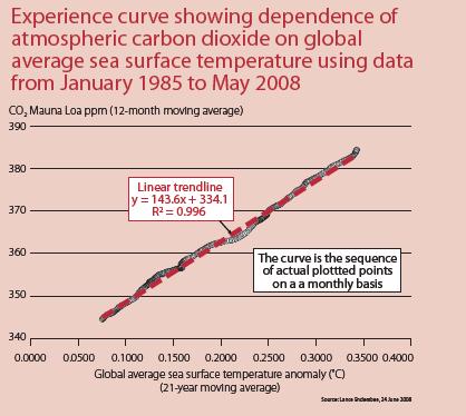
The interaction of the atmosphere and the oceans is essentially a phenomenon of the ocean surface. It would be expected that there would be almost a direct correlation between levels of CO2 in the air and the global mean sea surface temperatures, and that is the case. It is possible to plot an experience curve of the relationship between ocean temperatures and atmospheric CO2 levels. In order to do so it is necessary to recognise that the oceans have a vast storage capacity for heat and dissolved gases, and that changes are slow. On the other hand, the atmosphere has a much more rapid response time. If we use a 12-month moving average of atmospheric CO2 and a 21-year moving average of the more accurate recent data on global average sea surface temperatures, a remarkably clear experience curve is obtained. The 12-month moving average of CO2 levels filters out the variations of the annual cycle and, in related analyses, provides a view of the influence of other natural events. The 21-year moving average of sea surface temperature covers the complete solar cycle, including the change in magnetic polarity of the sun, the El Nino and La Nina influences on global climate, and recognises the vast storage capacity of the oceans for CO2 and the slow response time of the oceans.
The chart shows that the CO2 levels in the atmosphere and global average sea surface temperatures are locked together. The correlation is so firm it is reasonable to include it as a condition in the computer simulations used to study climate change.
Se larger image here
It is my view that the present fear of man-made climate change is quite mistaken. We should try harder to understand the real causes of natural climate change.
Lance Endersbee
Emeritus Professor Endersbee AO, FTSE, is a civil engineer and his early professional career included 27 years in engineering practice followed by 13 years at Monash University. His career in engineering practice included service with the Snowy Mountains Hydro-Electric Authority, the Hydro-Electric Commission of Tasmania and the United Nations in South-East Asia as an expert on dam design and hydro power development. He is now active on conceptual plans for several major new national engineering projects directed to Australian national economic and social development.
Peter
Carbon Dioxide and the Oceans
Dr. Lance Endersbee in Focus
Should we try harder to understand the causes of natural climate change instead of assuming present climate change is man-made? In the past, sea temperatures were obtained from measurements by passing ships in the sea lanes of the world. It is only in the past three decades that more accurate data on sea surface temperatures has become available. The analysis of this recent data by the author shows that: � the oceans regulate the composition of the atmosphere; the influence on climate of human-generated carbon dioxide (CO2) in the atmosphere is negligible; and global climate change has natural causes. The oceans and the atmosphere are quite shallow in relation to the vast surface area of the oceans.
The interaction of the atmosphere and the oceans is essentially a phenomenon of the ocean surface. It would be expected that there would be almost a direct correlation between levels of CO2 in the air and the global mean sea surface temperatures, and that is the case. It is possible to plot an experience curve of the relationship between ocean temperatures and atmospheric CO2 levels. In order to do so it is necessary to recognise that the oceans have a vast storage capacity for heat and dissolved gases, and that changes are slow. On the other hand, the atmosphere has a much more rapid response time. If we use a 12-month moving average of atmospheric CO2 and a 21-year moving average of the more accurate recent data on global average sea surface temperatures, a remarkably clear experience curve is obtained. The 12-month moving average of CO2 levels filters out the variations of the annual cycle and, in related analyses, provides a view of the influence of other natural events. The 21-year moving average of sea surface temperature covers the complete solar cycle, including the change in magnetic polarity of the sun, the El Nino and La Nina influences on global climate, and recognises the vast storage capacity of the oceans for CO2 and the slow response time of the oceans.
The chart shows that the CO2 levels in the atmosphere and global average sea surface temperatures are locked together. The correlation is so firm it is reasonable to include it as a condition in the computer simulations used to study climate change.
Se larger image here
It is my view that the present fear of man-made climate change is quite mistaken. We should try harder to understand the real causes of natural climate change.
Lance Endersbee
Emeritus Professor Endersbee AO, FTSE, is a civil engineer and his early professional career included 27 years in engineering practice followed by 13 years at Monash University. His career in engineering practice included service with the Snowy Mountains Hydro-Electric Authority, the Hydro-Electric Commission of Tasmania and the United Nations in South-East Asia as an expert on dam design and hydro power development. He is now active on conceptual plans for several major new national engineering projects directed to Australian national economic and social development.
Monday, August 4, 2008
Mysterious Mother Nature
What causes these rocks to move? Is it global warming? Well, yes, in a way. Most of the valleys in the Nevada and California Basin and Range Province contained large lakes filled with water from melting glaciers covering the surrounding mountains during the last Ice Age. This is known as The Wisconsin Ice Age in North America and the Wurm Ice Age in Europe. (Search this blog for Lake Lahontan, for more information.)
One question is "how did the rocks get out onto the lake beds in the first place?" They probably rolled down the mountainsides due to natural erosional processes and came to rest on floating lake ice. When the floating ice melted and moved during the spring or summers, the rocks would sink to the bottom.
Now, what causes them to move? From personal experience I know that when the clay on the surface of these dry lake beds gets wet, like after a rainstorm, the clay becomes incredibly slippery. The best guess is when these slick, low-friction conditions are combined with high winds, the rocks slide across the surface, leaving these tell-tale tracks. Why hasn't anyone seen them move? You can not get out on the lake beds when they are wet. So in a way, these mysterious tracks are "caused" by global warming.
Peter
Someone sent this to me...
Subject: ANYONE HAVE AN ANSWER FOR THIS PHENOMENA????
MOVING ROCKS Thought this was a joke, googled it and found
"smithsonian study of moving rocks of death valley" says it is true........ http://mmmgroup.altervista.org/e-rocks.html
The moving rocks, also known as sliding rocks or sailing stones, are a geological phenomenon found in Racetrack Playa, a seasonally dry lake (a playa) located in the Panamint Mountains in Death Valley National Park , California . The rocks move across the surface of the playa, leaving long tracks behind them as they go, without human or an imal intervention. They have never been seen or filmed in motion.


 Racetrack rocks only move once every two or three years and most tracks last for just three or four years. Rocks with rough bottoms leave straight striated tracks while those with smooth bottoms wander.Most of the moving stones originate from an 850 foot (260 m) high hillside made of dark dolomite on the south end of the playa, but some are intrusive igneous rock from adjacent slopes. Tracks are often tens to hundreds of feet (low to high tens of meters) long, a few to 12 inches (8 to 30 cm) wide, and typically less than an inch (2.5 cm) deep.


Over the years there were many speculations and possible explanations made on how the stones move, ranging from supernatural to very complex. Most hypotheses favoured by interested geologists posit that strong winds when the mud is wet are at least in part responsible. But some stones weigh as much as a human, which some researchers feel is too heavy for the area's wind to move. They maintain that ice sheets around the stones either help to catch the wind or move in ice flows.But both theories don't explain how two rocks right next to each other could go in two opposite directions or one could stay put while the one three times the size, doesn't. So far every attempt of explanation has been insufficient and purely assumptive. The mystery of moving rocks is yet to be revealed.


One question is "how did the rocks get out onto the lake beds in the first place?" They probably rolled down the mountainsides due to natural erosional processes and came to rest on floating lake ice. When the floating ice melted and moved during the spring or summers, the rocks would sink to the bottom.
Now, what causes them to move? From personal experience I know that when the clay on the surface of these dry lake beds gets wet, like after a rainstorm, the clay becomes incredibly slippery. The best guess is when these slick, low-friction conditions are combined with high winds, the rocks slide across the surface, leaving these tell-tale tracks. Why hasn't anyone seen them move? You can not get out on the lake beds when they are wet. So in a way, these mysterious tracks are "caused" by global warming.
Peter
Someone sent this to me...
Subject: ANYONE HAVE AN ANSWER FOR THIS PHENOMENA????
MOVING ROCKS Thought this was a joke, googled it and found
"smithsonian study of moving rocks of death valley" says it is true........ http://mmmgroup.altervista.org/e-rocks.html
The moving rocks, also known as sliding rocks or sailing stones, are a geological phenomenon found in Racetrack Playa, a seasonally dry lake (a playa) located in the Panamint Mountains in Death Valley National Park , California . The rocks move across the surface of the playa, leaving long tracks behind them as they go, without human or an imal intervention. They have never been seen or filmed in motion.

 Racetrack rocks only move once every two or three years and most tracks last for just three or four years. Rocks with rough bottoms leave straight striated tracks while those with smooth bottoms wander.Most of the moving stones originate from an 850 foot (260 m) high hillside made of dark dolomite on the south end of the playa, but some are intrusive igneous rock from adjacent slopes. Tracks are often tens to hundreds of feet (low to high tens of meters) long, a few to 12 inches (8 to 30 cm) wide, and typically less than an inch (2.5 cm) deep.

Over the years there were many speculations and possible explanations made on how the stones move, ranging from supernatural to very complex. Most hypotheses favoured by interested geologists posit that strong winds when the mud is wet are at least in part responsible. But some stones weigh as much as a human, which some researchers feel is too heavy for the area's wind to move. They maintain that ice sheets around the stones either help to catch the wind or move in ice flows.But both theories don't explain how two rocks right next to each other could go in two opposite directions or one could stay put while the one three times the size, doesn't. So far every attempt of explanation has been insufficient and purely assumptive. The mystery of moving rocks is yet to be revealed.


Death Valley geology field trip
Racetrack Playa
A sliding rock and its trail cut across Racetrack Playa. Photo by Marli Miller
The mysterious sliding rocks of Racetrack PlayaThe level surface of this parched basin provides the backdrop for one of Death Valley's most intriguing geological puzzles, the mysterious sliding rocks of Racetrack Playa. Scattered across the extraordinarily flat surface of Racetrack Playa, far from the edges of the surrounding mountains are boulders, some up to 320 kg (705 lb), and smaller pieces of rock. Stretching behind many of the stones you'll see grooved trails. Some are short, some long, some straight, some curvy. Clearly, these rocks must gouge furrows as they slide across the playa surface, yet no living person has ever witnessed these amazing rocks move! What makes these rocks skid as much as 880 meters (2890 ft.) across the flat playa surface? Recent scientific sleuthing provides some answers.
Satellite image of Racetrack Playa. The Last Chance range is on the left, Cottonwood mountains to the right of the light-colored playa surface.
Racetrack Playa
A sliding rock and its trail cut across Racetrack Playa. Photo by Marli Miller
The mysterious sliding rocks of Racetrack PlayaThe level surface of this parched basin provides the backdrop for one of Death Valley's most intriguing geological puzzles, the mysterious sliding rocks of Racetrack Playa. Scattered across the extraordinarily flat surface of Racetrack Playa, far from the edges of the surrounding mountains are boulders, some up to 320 kg (705 lb), and smaller pieces of rock. Stretching behind many of the stones you'll see grooved trails. Some are short, some long, some straight, some curvy. Clearly, these rocks must gouge furrows as they slide across the playa surface, yet no living person has ever witnessed these amazing rocks move! What makes these rocks skid as much as 880 meters (2890 ft.) across the flat playa surface? Recent scientific sleuthing provides some answers.
Satellite image of Racetrack Playa. The Last Chance range is on the left, Cottonwood mountains to the right of the light-colored playa surface.
The playa surface
Racetrack Playa is an almost perfectly flat dry lake bed nestled between the Cottonwood Mountains to the east and the Last Chance Range to the west. During periods of heavy rain, water washes down from nearby mountain slopes onto the playa, forming a shallow, short-lived lake. Under the hot Death Valley sun, the thin veneer of water quickly evaporates, leaving behind a layer of soft mud. As the mud dries, it shrinks and cracks into a mosaic of interlocking polygons.
Polygonal mudcracks form as mud dries in Racetrack Playa. Photo by Marli Miller
source
Racetrack Playa is an almost perfectly flat dry lake bed nestled between the Cottonwood Mountains to the east and the Last Chance Range to the west. During periods of heavy rain, water washes down from nearby mountain slopes onto the playa, forming a shallow, short-lived lake. Under the hot Death Valley sun, the thin veneer of water quickly evaporates, leaving behind a layer of soft mud. As the mud dries, it shrinks and cracks into a mosaic of interlocking polygons.
Polygonal mudcracks form as mud dries in Racetrack Playa. Photo by Marli Miller
source
Sunday, August 3, 2008
Being Green?
From my sister blog, "The Fellowship of Scientific Truth"...
Penn and Teller..Being Green?
Brilliant, insightful and profane, but a "must watch". Click on the following title, "Being Green"
Peter
Penn & Teller's Bullsh**!:"Being Green"
Penn and Teller..Being Green?
Brilliant, insightful and profane, but a "must watch". Click on the following title, "Being Green"
Peter
Penn & Teller's Bullsh**!:"Being Green"
Subscribe to:
Posts (Atom)